|
|

|
Driving to Palomar Observatory
The Observatory is located within the Cleveland National Forest on Palomar Mountain in North San Diego County at an elevation of 5,598 feet (1,702 meters) above sea level. Our street address is:
Palomar Observatory
35899 Canfield Road
Palomar Mountain, CA 92060-0200
This Google Maps link will do a good job of providing custom directions (see "Get directions").
Please be aware that some on-line and GPS programs can give incorrect directions to Palomar Observatory. We recommend consulting the Google Maps link given above.
If the Google link above doesn't help, please use the directions below.
From the Los Angeles or San Diego areas
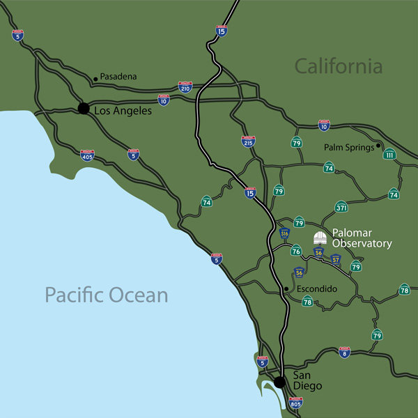
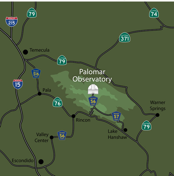
Exit Interstate 15 at state highway 76 eastbound. Follow the signs to Palomar Mountain. Twenty five miles (40 km) from the interchange, County Road S6 (also known as South Grade Road) exits (5 miles/8 km past Valley Center Road) in a "Y" to the left and climbs to the Palomar summit. S6 ends at the Observatory gates.
From the Palm Springs area
Take Route 74 west to 371 south, then Route 79 east and south (toward Indio), then Route 76 west to S7 up to Palomar Mountain and after 11 miles (18 km) on S7 bear right onto S6 another 4.5 miles (7 km) to the Observatory parking lot.
We have road maps to help you find your way here:
- Southern California road map [jpg, pdf]
- Palomar Observatory on Google Maps
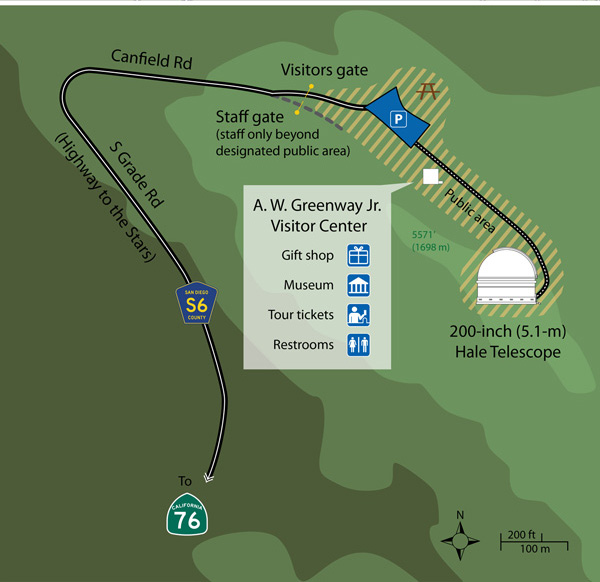
Visitor parking is only available in the visitor parking lot; please keep left at the entry way. Visitor overnight parking is not permitted at the Observatory, and the visitor parking lot will be closed and locked promptly at 3:00 pm PST (3:30 pm PDT).
As you walk up the path to the Hale Telescope dome, the Addison White Greenway, Jr. Visitor Center and Gift Shop will be on your right.
Important Notes
- County Road S6 is a mountain road with many curves. Please drive carefully. Watch for fog, fallen rocks on the road, especially during and immediately after rainfall. Travel on Highway 76 and South Grade Road (S6) may be difficult during and just after rain events. Road closures and rock/mud slides are possible at these times.
- Winter storms usually mean snow and icy conditions on Palomar and generally, in these circumstances, tire chains are required by the Highway Patrol. Again, please drive with caution.
- The Observatory will be closed in the event of hazardous travel conditions. When possible, our homepage will be updated to announce any closures. In addition, please refer to the listing of official information sources given below.
- Visitors are strongly urged to pay close attention to signs indicating the Observatory's closure to visitors that may be posted on the bottom of South Grade Road (S6), East Grade Road (S7), and at the S6 "summit" location approximately 4.2 miles (6.7 km) south of the Observatory.
- There are no gas stations on Palomar Mountain. Check your fuel before driving to the Observatory.
- Approximate driving times (non-rush hour) to the Observatory are:
| From the Los Angeles area | 3 hours |
| From downtown San Diego | 2 hours |
| From Escondido | 1 hour |
| From Temecula | 1 hour |
Current Information on Road Conditions
Please check the following links:
Questions? We've answered many common visiting, media, and academic questions in our public FAQ page.
Please share your feedback on this page at the
COO Feedback portal.
Driving Directions / v 1.0.6
Last updated: 26 September 2023 ACM
|
|
|


